Sunday, August 5, 2012

Sommerlesung: Insuring the City


©2008 Bauzeitgeist.

Occasionally, a visit to the bookstore, for those who happen to live in a place where such an errand is even possible, results in a discovery of a newly published book which is unexpected in a euphoric but somewhat devastating way. The existence of a volume on a subject so esoteric that the idea that you alone were interested in it was plausible, is a source of joy; that this insensible idea is dashed by the presence of the book on the shelf is a cause for surprise, and the small lament that you are no longer the lone expert on this particular topic (and therefore, with the discovery of this newly-published book, not the one to write the definitive account of the subject? Perhaps a cause for a small but powerful sadness).

©2008 Bauzeitgeist. 

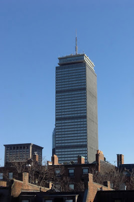
Even if none of that makes any sense, never mind. Here is a book to read: Insuring the City: The Prudential Center and the Postwar Urban Landscape, by Elihu Rubin, published by Yale University Press earlier this year. The book tells the story of the Prudential Center, one of the largest office buildings and commercial developments ever realized in Boston or New England, chronicling the economic, commercial, social, urban, political and architectural thoughts and movements that brought about this unusual tower and the multi acre "Prudential Center" arranged at its ankles in the center of Boston's midtown Back Bay district. 

©2008 Bauzeitgeist.   

I lived in Boston for many years. It was my first city-- my first time living in a city as an adult. I lived only a few blocks from the Prudential, and in more than one apartment had a view of the silver-grey-green bulk which towered over the red brick and rooftops of the older townhouses of the area. I can't say I came to love the building, but was certainly always fascinated by it, its hideous metallic grille body, its weird, anthropomorphic capital, crowned with dozens of antennae, and embossed with a corporate label as if a slip of paper had passed through a massive typewriter. The building seems to so rudely destroy the historic charm of the Back Bay's mannered, leafy streets, and yet is itself somehow hopeful and silly, broadcasting its simplistic, vintage optimism.

 ©2008 Bauzeitgeist.

That the Prudential Center is so ignored, unloved and loathed a landmark  in the common estimation of both Boston's citizens and visitors, which was produced nearly 70 years ago by an unappreciated, no-name corporate architect, certainly makes it an unusual subject of a full publication of academic architectural enquiry. That an architectural historian has successfully brought to print a novel-sized volume on not only this building's history but a footnoted account of its creation and execution is equally too infrequent. 

 ©2007 Bauzeitgeist.

In five thoroughly researched chapters, Rubin details the architectural heritage of the Prudential Insurance Company of America, particularly its nationwide Home Office expansion program, which resulted in striking if rather conservative new office blocks in Newark, Los Angeles, Chicago, Houston, Jacksonville, and Minneapolis. To see a major corporation undertake a multi city building program in the midst of America's urban abandonment, and to have this occur for specifically pro-urban reasons, underscores how different corporate citizenship was seventy years ago from today. For more on this, see the inevitable Atlantic Cities post on the topic, in a review the book from June, which includes a reply in the comments section from the author himself.

 ©2008 Bauzeitgeist. 

Rubin devotes two chapter to the social and political environment of Boston at mid-century, when a parochial backwardness thwarted the implementation of modern architecture in the historic city, which was followed by a corrupt political machine. The book passes briefly over the sudden, shocking arrival of modernist urban renewal in Boston by momentarily referencing the West End, Government Center, and the Central Artery, all of which involved expunging huge areas of the centuries-old core of the city and interrupting the historic street pattern. It would be interesting to juxtapose these more thoroughly, along with the subsequent Christian Science Center near the Prudential, to show them as one class of similar urban renewal upheavals. 

The Prudential from South Boston. ©2012 Bauzeitgeist.

The book stays on topic, detailing the state and local tax schemes which kept the Prudential project alive. The final chapter reflects on the intervening time since the initial construction, in which the towers in the park Prudential Center was first revitalized as an upscale shopping mall, a program which remains in place today to great success, and in the last ten years has resulted in smoothing out the edges of this originally-inward-looking  development. 
The Back Bay Skyline from the Charles River. ©2010 Bauzeitgeist.

If there is one complaint about the book, its that this ending is rather rushed: although the later 1980s, 1990s, and 2000s additions are mentioned in the last few pages, a more thorough architectural examination of the changes to the character and function of the whole center by these changes would have been welcome. These projects are nearing an end, as the last available spaces in the Prudential Center have been filled in or spoken for, but it is interesting to look at this three-decade maturing and how it reflected changing social attitudes toward city centers, as the modernist plan of multistory retail plazas and prospects, good in theory but dreary and windswept when opened, were internalized into a suburban style mall. A later era, just passed, saw the addition of new luxury condominium towers (there were always luxury apartment buildings on the site) which lastly culminated in the addition of the Mandarin Oriental Hotel & Residences in the mid-2000s, which was not only one of the most prominent developments in Boston during the recent real estate boom, but also created a traditional urban street facade along Boylston street where previously there had been a driveway. 
The Prudential Center shown in axonometric on a Transit Authority 
wayfinding placard at Back Bay Station. ©2010 Bauzeitgeist.

The only other complaint about the book, and the more significant one: the novel-sized publication contains only black and white photos, and most of these are tiny, and pushed to the edges of each page by lengthy blocks of text. Vast panoramas of the Boston skyline, and presentation drawings that are surely huge in their original form, are  miniscule. This is a shame; perhaps the publication could have done with a series of plates in the center. This would have had the additional effect of showing some affection to the building itself, which remains a prominent landmark in Boston, yet one that is universally unappreciated.
The Prudential in a wooden model of the city of Boston
by the Boston Redevelopment Authority. 
The Mandarin Oriental Hotel is the two mid rise blocks at the center of the picture, 
to the front and left of the Prudential Tower. ©2009 Bauzeitgeist. 

Insuring the City isn't a typical read for any audience: its neither a general interest publication, nor is it the sort of books architects usually buy. Its not theory, and its not a coffee table monograph. Its dozens of pages of text only interrupted by subheadings like "The Bond Market" or "The Pubic Authority Model" or "Toward a Tax Concession." But this is also what makes the book so worthwhile, so important, so relevant, and so recommendable, for if chapters about creating a special purpose vehicle for a major corporation to develop a multi acre urban site isn't the typical book that architects pick up (much less write), perhaps it should be. This, I believe, is exactly the sort of subjects that architects remain ignorant to their own professional detriment: this is the story of how major projects actually get done, in American cities as elsewhere, a tale which is usually the saga of clever developers and willing public officials than it is of architects taking a lead role. In what is left of the summer, I'd suggest this is exactly the sort of book that architects should be taking to the beach. 

Tuesday, July 31, 2012

The Most Architectural Country on CNN


Another post-Soviet, Eurasian state that has both built iconic architecture and made these landmarks the central focus of advertisements shown on CNN is the Republic of Georgia. There are several advertisements for the Republic of Georgia that have appeared on CNN over the last few years. Recent iterations (many viewable, but not embeddible from the Invest in Georgia website) such as the one titled Why Georgia is Different showcase the country's recently completed glass halls and gilded towers. Another, not posted to the site, shows one the country's 80 newly-constructed, glass-enclosed police stations, and underscores this architectural metaphor as part of the state's commitment to transparency and anti-corruption.


Georgia is fairly unique as a small, developing country without any particular resource boom that has undertaken a nationwide construction of new public facilities. While this might make the pages of the Financial Times, that the Republic's recent buildings feature the stylish attempts at avant-garde form-making from such celebrity firms as UNStudio and J. Meyer H. make this fertile eye-candy for the light-speed semi-pro architectural blogosphere, the universe of DesignBoom and its siblings.

Police Station in Mestia, Georgia. 
Designed by Jurgen Mayer H. images via this website, April 2012.

 Terminal Building for the Airport at Mestia, Georgia. 
Designed by Jurgen Meyer H. Via Dezeen, November 2011.


This has given the leading architecture blogs a little geographic variety in their usual line up: The Fox Is Black recently featured a rest stop along a Caucasian highway designed by J. Meyer H., and last November FastCo Design decided on titling a post: Georgia Builds the World's Wackiest Border Crossing (the childish title is actually better than the horrid copy of the rest of post), which featured another JMH design of what is certainly rather delightful for a border crossing, although it adheres to the cookie-cutter mold look that makes JMH's buildings more punny than clever.


Border Checkpoint at Sarpi, Georgia. 
Designed by Jurgen Mayer H. images via Dezeen, January 2011.

 The 'Georgia' geographic tag on Dezeen in particular is an easy reference for Georgia's new landmarks. That Georgia's remote airfields have luscious terminal halls worthy of Wallpaper, thought up by some of Europe's most popular architectural talents, is remarkable by itself. Less celebrated is the Ministry of the Interior, situated outside of the capital on the way to the airport, with a half-hearted attempt at showmanship via its undulated glass, looking like a new-built office park anywhere, but proudly displaying its gesture of government openness and accessibility via its shiny exterior.

 
Ministry of Internal Affairs, Kakheti Highway, Georgia, by Michele de Lucchi.

In a similar way to Azerbaijan and Kazakhstan, this whole effort, which must be expensive, comes across as a whole lot of marketing. Georgia is working hard to attract investment, with a website and a series of CNN commercials that seem designed solely to increase the country's standings in the World Bank's Doing Business Rankings, a phenomenon that has grown in the last five years to a bizarre fixation. Georgia isn't, ultimately, a wealthy country, and sits in a troubled region. This is before considering the fact that an autonomous region of the country declared its independence, with Russia's encouragement, and the country was invaded and humiliated by its giant former ruling power just as the first of these projects was commissioned.


Renderings for the Border Checkpoint at Ninotsminda, Georgia via Dezeen, July 2012.  


So, rather than giggle at why a border post is in the outline of a giant squiggle, one might start raising critical questions such as why Georgia needs such a monumental pile guarding the borders with Turkey at all, or whether its remote corners of the Caucaus need air terminals which look nicer than first class lounges at major hubs. Its unquestionable that Georgia's infrastructure budget might have been put to use elsewhere, perhaps more generally in providing services to its citizens. There has been some investigation into how one of these new architectural designs comes about and why realizing one will cost 66% more than the Ministry of Agriculture's entire budget. 

Speculatively, it is easy to imagine that Georgia's leadership is focussed on investment-fuelled growth, and that blog-ready infrastructural projects might have a singular ability to brand Georgia as a progressive, cool country. But these undertakings are also surely profitable for national construction companies  and land developers. Exactly who in Georgia truly benefits from this is not obviously, and as the above-article makes clear, the answers are not forthcoming from the various government entities which have suddenly taken an interest in awarding jobs to hip architects from central Europe. Whether this is all the worthy endeavors of strengthening a young, weak, isolated state, or another iteration of cronyism is not currently clear, but what is lucid from Georgia's current architectural infatuations is that Georgia may not, in fact, be different and that it takes more than a curtain wall of glass to make democracy and development more transparent.

Thursday, July 26, 2012

Land aus Feuer und Hochhäuser

CNN International has a particular roster of advertisements. Most likely due to its widespread, worldly audience as one of the planet's principal satellite news networks, for years CNN has featured commercials not for cars or canned goods but for countries. A random collection from recent broadcasting includes tourism and promotional ads featuring Taiwan, Singapore, Qatar, and Montenegro.

This leads to some unusual advertising arrangements. "Arrangements" seems the correct terms as the network not only airs commercials during programming breaks, but also has embarked on favorable, sponsored coverage on the economic and investment climate of sovereign states, a somewhat behind-the-curtains practice which was revealed by Max Fisher in the Atlantic in the last week.

The Atlantic article specifically called out some unusual editorial arrangements in which former or even current regime officials in Kazakhstan were interviewed as experts and commentators on Kazakhstan's attractiveness to foreign investors.

Even before this controversy surfaced, I had wanted to post two ads in particular here: one for Azerbaijan and one for Astana, capital of Kazakhstan. Both feature recently-completed contemporary architecture quite prominently.

The Azerbaijani advert is a more straightforward pitch to the business traveler: zip to Azerbaijan for the day on your Citation, seal an investment opportunity by sunset. While there is some of footage of the sandstone buildings of the old city of Baku, that capital's newest addition, the Flame Towers, are unmissable: the towers shown no less than 5 times, and form the backdrop of the conclusion of the ad. As the names make obvious, the towers are supposed to resemble flickering fire, a reference to the country's Zoroastrian fire-worshipping heritage.

However, with their blue-green glass slimming upwards, the resemblance to the Financial Harbor Towers in Bahrain, (previously blogged about here) although likely unintentional, is unmistakable, and the effect of booming Baku having a Bahrain- or Dubai-style skyscraper set was surely part of the allure of their addition to the skyline.


The second advert shows the instant-city-on-the-steppes, Astana, the circa 1997 capital of Kazakhstan, an immense country which boasts even more extraction-action than Azerbaijan. The ad is similarly storyboarded if slightly less overtly financial. It is mainly some cloudless vistas of the capital's glistening new towers, aligned on what is surely, during the long sub-Siberian winter, a frigidly-windswept central promenade: apparently called the Green Water Boulevard or Shining Path, which is the central part of the city's master plan, designed by Kisho Kurokawa.

The camera rests as 0:25 on Norman Foster's Khan Shatyr Entertainment Center, an indoor beach resort and shopping center (again, that winter), but the footage doesn't show Foster's other Astana edifice, the pyramidal Palace of Peace and Reconciliation, perhaps because that slightly older structure has less permanent use (This 2010 Blueprint Magazine article thoroughly covers the story of Foster in Kazakhstan.


I've posted previously about Astana, and the Kazakhstani government's use of architecture to visually promote trade. The prominence of contemporary architecture, putting its "iconic" these emerging economies as worthy business destinations, is neither a particularly new or unique use of architecture. In fact, as much as it boasts of where the global growth seems to be these days, it also evinces the come-from-behind status of these investment frontiers, in comparison to more established markets. Its hard imagine that places such as Milan or Los Angeles would either need television commercials or have them feature recently-constructed buildings to reassure potential investors; but then American and European cities hardly have the budgets to buy spots on CNN, and the government would have to answer to its own constituents if its spent taxpayer money on a TV spot. The leaders of Azerbaijan and Kazakhstan don't have to worry about that.

Sunday, July 8, 2012

Shardenfreude

 Around 40 architectural landmarks are arranged to make a heart. 
If the Shard is among them, it is the small, dark pylon at the bottom, underneath
 the Tower Bridge, to the left of Nelson's column. The London Eye, the Gherkin, 
Natwest Tower and even the Carbuncle Cup-winning Strata are more prominent. 

Liebt niemand die Shard? 

It was actually not difficult to find favorable words for London's newest, tallest tower in the press leading up to last week's opening, but most of the platitudes emanate from the building's builders, backers, and its architect. 

The opening ceremony, in which the Shard had frickin' laser beams coming out of its head, was actually a quite fitting metaphor for the building: somewhat cheesy, ostentatious, unoriginal, self-important, and unable to be avoided even far across London.

The Shard's baptism by beacons occurred in the same week as the "LIE-BOR" scandal oozed out of London and around the world, and the building's constant honorific--the tallest building in Europe-- is spoken in a period when the very word "Europe" is a source of anxiety in a way unimaginable a decade ago. Similarly, a metropolis that had long-since sold its Georgian squares to Kuwaitis, and its department stores to Egyptians, and allowed the Saudis, Russians, Qataris and others to own and build so much of the city, now see this foreign control as endless and out of control. It is a tower of luxury in a city and country divided by wealth and privilege.

And yet, here it is, London's newest tower, meant to be a towering symbol of London's continued relevance, renewal, and righteousness. Yet a comparison of the completion of the Shard with the arrival of the Gherkin less than a decade ago reveals two completely different receptions. The juxtaposition is an apt one: the Gherkin was the most prominent addition to London's skyline in years, and furthermore is just more glass-enclosed office space for foreign financial firms, like the Shard. Yet the very different regard for these two towers is remarkable.

The Gherkin, firstly, did not rise in a controversial area: The Gherkin rose in the existing business district, among a shiny cluster of financial office blocks that had walled off the City since the 1970s. It was not even the tallest spire among these, whereas the Shard looms alone over the streets of Southwark.

Even before it was finished in 2004, the Swiss Re: Headquarters was granted a giggle-inducting name of an edible delight that doubles as an erotic euphemism (although its true that some people don't regard the name as a mark of admiration and it is certainly true that funny nicknames are not given to London skyscrapers purely out of affection). And yet the Shard is not a nickname by the public and press: it is the official name of the building, a central aspect of its polished marketing. And while the Gherkin brings to mind salacious and sundry associations, a Shard of glass comes from the violent cracking of a pane, a shattering: its broken pieces sharp and skin-slicing: a horror-movie weapon, not a silly sexual slang. 

If the appellation is just unimportant, the origin story is not, and the Gherkin is more British than the Shard will ever be. Designed by a British architect, a Lord no less (in a slightly more innocent, pre-MP expenses and pre-phone hacking era which had less disdain for the wealthy and more regard for Parliament). Even its address, St. Mary's Axe, was atavistic and adorable, suggesting both the christian shrines of the pre-modern City and the quirky serendipity of English geography (what other nation names an alley an axe?).

Finally, its swirling strips of climate-controlling rhomboid glass curtain recall the lead-paneled windows of Tudor timber-frames that the district once had, bridging its most futuristic feature with the ancient heritage of the area: the Gherkin managed to be both forward-looking yet quintessentially British (whereas the Shard has been accused of being not just Qatari but North Korean).

In this patriotic fable, the Gherkin embodied the core sentiment of London's fin-de-siecle self-satisfactory myth and self-congratulatory mood that swept over the city: London, ancient, creaking, damp, and increasingly diminutive, had remained atop the rankings of the most important, relevant, modern, and cool cities in the world. Indeed, London, long-past its prime as the capital of empire, had remained the center of the world.


Online Adverts for Iceland Express airlines, c.2009. 
London is shown by Westminster Cathedral, the Tower, Big Ben, St. Paul's,
 and most prominently the London Eye and the Gherkin.


It was that the Gherkin, along with its earlier contemporary, the London Eye, a similarly-circular and equally-visible contemporary, that were the celebrated as symbols of this triumph. Both were cute: a plump priapsism of late-cool Brittania exuberance, with the Eye as its sister iteration, a childlike-carnival ride over the Thames, just opposite Westminster.


The Vivian Westwood Christmas display window at Selfridge's Department Store, 
Oxford Street, London, December 2005. 
The London Eye, The Monument, St. Paul's Cathedral, 
the BT/Post Office Tower, and Charing Cross are all discernible. ©2005 Bauzeitgeist.

Landmarks they became, and symbols they remain. The Gherkin and the Eye took their place among the pantheon of London's architectural idols in print, posters, advertisements, and other media, joining its elders St. Paul, Big Ben, the Monument, and Tower Bridge. The Gherkin popped up across the visual landscape of London in those years, and still does today, in the constant graphic representation of the skyline, and by extension, a city and country enjoying a renaissance of its own ingenuity.

 Above: An advert on a tube escalator, December 2005, showing 
St. Paul's, the Gherkin, and the Tower Bridge. 

Above: Great Southwest Trains billboard at Waterloo Station, February 2006. 
The skyline shows the Houses of Parliament, Westminster, Nelsons' column, 
the Eros fountain, St. Paul's, the Monument, the Gherkin, the London Eye, and Tower Bridge. 

 Above: A commemorative Kitkat bar box, c.2010. 
St. Paul's, One Canada Wharf, and The Gherkin stand for London.

Above: two posters for the 2007 Tour de France in London. 
The Gherkin is the most prominent landmark shown, 
but Lloyds of London makes an appearance.

Quite awkwardly, the Shard has yet to receive such graphic laurels. The supertall was deliberately crafted to be an icon of the city, yet thus far there are hardly any outlines of London's skyline, whether within the UK or elsewhere, that include it.

A mural on 5th Avenue, New York, in January 2012, advertising 
the opening of a Ted Baker clothing emporium. Robot mannequins 
trim a hedgerow into the shapes of London landmarks: 
Lord Nelson, Buckingham Palace, the London Eye, St. Paul's Big Ben, 
Westminster Cathedral, Eros, Tower Bridge, and the Gherkin.

Even the hideously unloved Natwest Tower, the thoughtless trifecta of Canary Wharf, the heinously bizarre city hall helmet, and the long-loathed and utterly defunct BT Tower appear more often (interestingly, the 3-year old Heron Tower, officially the city's tallest but with even less to distinguish itself than the drab Natwest Tower, has not been adopted, either).But it is constantly the Gherkin and the Eye that are purposefully included to indicate the contemporary city.


Above: ©Artist unknown, c.2009 via this tumblr
 Both use the ensemble of St. Paul's 
the Gherkin, and Natwest to represent London.

Compared to the much less frequent examples incorporating the Shard:
Albert Hall and Wembley Stadium, alongside
The Gherkin, the London Eye, Big Ben and Tower Bridge. The Shard is also prominent.


Above: The Londonist, a widely-read events blog, is one of the first and few to incorporate the Shard 
into its logo, alongside Big Ben, the Eye, the Gherkin and St. Paul's dome.

The lack of acceptance of the Shard is especially remarkable in the year 2012, when London and the rest of Britain, were are told, will be renewed via the magic of the Olympics. The Shard already has an awkward relationship to this spectacle, in that it actually has nothing to do with the Olympics at all, but is being finished in the same year and that the Olympic games will occur in the same city. Last week's laser-show opening was a kickoff of the Olympics, just weeks away, but one that didn't make reference to the games at all.


 The Reporting from London, 2011. 
Top: Al Jazeera shows the Gherkin and the Tower Bridge. 
Above: SkyNews from the London Stock Exchange, showing St. Paul's, 
Tower 42, the Gherkin, and the towers of Canary Wharf.

The games have ratcheted up the provision of graphic representations of the city, even among those media groups which do not have official Olympic broadcasting, such as CNN and the BBC, but also by NBC Universal:

Above: CNNGo! celebrates London, 2012.The skyline is clearly made up of the London Eye, 
Westminster Cathedral and Big Ben, and the Tower Bridge, 
with the Gherkin and what may be the helmut-shaped city Hall on the underside.
Below: NBC's promotional trailer for the Summer Olympics. 
The opening sequence shows Big Ben, the London Eye, Buckingham Palace and the Gherkin, but not the Shard.  


All of these 2012-specific spots pay respects to the Gherkin and the Eye, along with the classic tourist landmarks such as Big Ben, Tower Bridge and St. Paul's, but none of them show the Shard, not even the BBC's non-Olympic Olympic extravaganza: "London Calling, The City of 2012" whose title animation shows One Canada Wharf and even the forever-loathed Centre Pointe, but does not include this year's debut tower:


The uplifting television advert, with panoramas of the Thames and long shots of a dozen London landmarks, especially St. Paul's and the London eye, shows the Shard only for a split-second in the background of a night vista:


Surely the Shard will be more widely depicted over time, when its presence is more in harmony with the mood of its city. Its not like its going anywhere, and in the future its initial associations will wear away. But it is this lack of inclusion thus far, the lack of celebration around its arrival, reveals that it is so disdained as to make its artistic ambassadors act as if it wasn't there.

Big brash buildings often take time fit in, especially in older, historic cities which fret over threats to the appearance of its ancient cityscape. But the faint praise for Piano's feat is due to more than just an uneasy reaction to this enormous erection's sun- and landmark-view blocking height or mass. Skyscrapers are landmarks, and landmarks are symbols, which by definition stand for something, and the creator cannot always declare the definitions. For an architectural gesture that was always designed to be an icon, it is the very fact that it is a symbol, and what it is a symbol of, that has made the Shard so unwelcome. 


Wednesday, June 27, 2012

Mehr aus Astana

Above image ©Google.

Normally I don't do links round-ups posts; nothing against them as they can be sort of useful, but in reading up on Astana there is some worthwhile reading elsewhere: Back in February The Polis Blog featured an interview with journalist John Lancaster, who speaks not only about glittery new Astana but also its older, pre-Nazarbeyev quarter, something of a dingy Right Bank of the city, as well as the environmental constraints on the burgeoning capital. Also in the same February, National Geographic featured an article by Lancaster, in typical NatGeo format, more for the layman but worth reading. This piece by Rowan Moore about Astana from the August 8th, 2010 Guardian is more for the architectural crowd.

Friday, September 30, 2011

African Borders & African States

This post is a slightly modified version of the "Foreign Correspondent's Report" that I submitted for the "Border Town/Divided Cities" design studio led by Emily Horne, of A Softer World, and Tim Maly, of Quiet Babylon, which was held in Toronto over the summer. Many thanks to them for allowing me to participate. --MMJ

Perhaps the most often-repeated sentiment about modern African states and the borders that demarcate them are that they were devised by European colonial powers, either as arbitrary lines on a blank canvas of lands and peoples which were unknown, or imposed to divide mercantilist, extractive spoils, or also to intentionally split apart existing kingdoms, chieftaincies, nations, tribes, and peoples in order to weaken and rule over them.
And this is mostly true, although the most nefarious conspiracies of a sophisticated coordination of parsing up a continent are a bit apocryphal. It is also helpful to compare the evolutions of nation-states and the divisions between ethnic groups elsewhere, including Europe itself, as such lines, although less arbitrary, have been subject to periodic, irregular alternations, not least due to war, aggression, empire-building, and subjugation.
European ignorance of or disregard for meaningful divisions that existed previously, especially between cultural groups, continues to have detrimental impacts on the modern states and populations they contain, Briefly, this post tried to illuminate several of the unique aspects that political and ethnic borders in Africa possess at the present time, and examine some the interactions between these different limits.
The creation of many African countries shares similar traits. The formation of various African countries evolved from the earliest European incursions into tropical Africa through to the post-colonial period. Juxtaposing chronological maps reveal many additions, subtractions, mergers and reformations which suggest the sculpting of a shape by carving, although the scalpel in hand was that of European political and economic affairs rather than a more natural or indigenous progression [see images of Cameroon below].
The evolution of the shape of Cameroon, from the German protectorate of Kamerun in 1910 above, to Anglo-French to French colony, to independent state in 1960.
The rough-hewn shape, looking much like the profile of a duck-billed,
crowned Parasauolophus dinosaur, is always existent but changes over time.
Top image courtesy of Wikipedia.
Firstly, European sea powers established forts and trading centers along the coast. Coincidently, more intrepid European explorers began penetrating the interior regions both from the Atlantic and Mediterranean (trans Saharan) ports, following either trade routes or rivers. It was not until the 20th century that European nations had more fully charted colonial boundaries inland.
For France in particular, the historic Atlas shows a claim to an immense and unexplored zone stretching from the Mediterranean to the Equator. Earlier Swedish, Dutch, Danish and Portuguese trading posts along the Ivory Coast, Gold Coast and Slave Coast gave way to the British Sea superiority during the Victorian era; German possessions were surrendered to the French and British victors after World War I.
LANGUAGE & ETHNICITY
Again due to the colonial legacy, West Africa is a checkerboard of Anglophone and Francophone countries (with a single, tiny, Lusophone state, Guinea-Bissau, in one corner). The former French colonies are highly aligned, using a common CFA Franc currency with a single central bank, and with the whole of West Africa operating the regional cooperative body ECOWAS [below]. But in matters between former British and French zones, the barrier of language has stunted better regional integration, particularly in terms of cross-border trade.

The Economic Community of West African States (ECOWAS)

This is evident when looking at route maps of regional airlines. For example, there is at least one flight per day on various airlines between Accra, the capital of English-speaking Ghana, and Monrovia, in English-speaking Liberia. The two nations are close allies and economic partners. However, these flights cross over French-speaking Cote D’Ivoire, and both cities have only a few flights per week to Abidjan, although it is one of the most important cities in all of French-speaking Africa, and Ghana and Cote D’Ivoire are about the same size.
When looking at the border regions themselves, the already-profuse polylingual abilities of many inhabitants will include knowledge of the legacy language of the neighboring country. For instance, people in Westernmost Ghana, in addition to speaking their own language, perhaps a few other indigenous African languages, and English, will speak French as well, due to the proximity of Cote D’Ivoire. In northern and eastern Liberia, it is common for many (illiterate) locals to speak French as well as English and their own tribal language.
This atmosphere in these frontier regions is further enhanced by the presence of a common ethnic identity or language on both sides of a national border—sometimes a single group has two different names in two different countries, such as the Dan/Mande/Gio in Liberia/Cote D’Ivoire. The international boundary is often a much newer phenomenon than the ethno-linguistic landscape of the area. A grandfather might have grandchildren living in the same area but in two different countries, and clan, kinship and ethnic links often straddle borders in West Africa.
CONFLICT
Such milieux have too often, unfortunately, not proven to be seams of regional stability, but have in recent decades (and recent months) become, and continue to be, zones in which insecurity, conflict and violence spill over borders. The clearest evidence of this is in Northeastern Liberia, especially in Nimba County. The first incident, in 1990, was the beginning of the two-decade long Liberia Civil War, with the crossing of the rebel warlord (and future elected president of Liberia; now in the Hague awaiting a verdict in his war crimes trial) Charles Taylor into Liberia from Cote D’Ivoire. This took place at the village of Buutuo.
Buutuo is also one of the locations of the second series of events, from this past winter and spring, as more than a million refugees fled political violence in Cote D’Ivoire, and sought shelter on the Liberian side of the border. Many of the villages, and even the very same families, which today host Ivorian refugees, were themselves refugees in Cote D’Ivoire in earlier years, fleeing the violence of the Liberian Civil War. There have been anecdotal reports this spring of Liberian families hosting the same Ivorian families which hosted them in previous decades.
The Ivorian refugee crisis, March 2011. ©2011 MM Jones
Conversely, family and clan links across borders make the spread of this same violence more fluid, especially in that it is easier to recruit rebel armies in these regions to launch hostile action in neighboring countries.
LIBERIA
Liberia is unique among African countries. Aside from Ethiopia (which was briefly conquered by Italy) Liberia is the oldest sovereign state in Africa, declaring its statehood in 1847. Liberia was founded not by Europeans but by freed American slaves and their descendants. These families and individuals came from both the northern and southern United States in waves, intermingling with the local tribes as well as the arrival of Africans freed from slave ships arrested along the coast.

The early evolution of what was later to be modern Liberia, from an unexplored area called Malagueta by the Portuguese (from an 18th century Dutch map, top) to a series of various American settlements along the "Grain Coast" which began to organize into neighboring units, reaching independence in 1847. At bottom is a modern map of Liberia showing the original American settlement zone.

Liberia’s original American settlements were all along the coast. For its first decades, these arrivals only established any type of control over a narrow sliver of what Europeans had first called Malagueta or the Grain Coast (various types of grain pepper were traded with Portuguese ships here). Various arrivals from different parts of the United States formed unassociated settlements, which only later came to be unified into Liberia.

During the remainder of the 19th Century (top) and the early 20th century (above), the large inland claim of independent Liberia is slowly chopped away by European powers in their rush to control the continent.
Even after independence, these settlements exerted hegemony only a few miles inland, but by claiming control over the coast, Liberia was able to monopolize access to the interior beyond yet on the map Liberia extended its territorial claim deep into the Guinea Highlands—a temperate, almost Alpine region that is the source of the greater River Niger. Liberia was never able to gain actual control over much of this interior area, which eventually became part of French Guinea (now the Republic of Guinea). Modern Liberia is about the size of Pennsylvania.
Liberia in 2008, showing its 15 counties.
INTERNAL BORDERS
Liberia has evolved not only as a sovereign entity in relation to external neighbors, but also in its internal arrangement, especially in the legacy of its American settlements and the relationship between these “Americo-Liberian” zones and the indigenous African tribes in the interior.
After independence, this interior of Liberia was divided into districts called Frontiers, a distinction reflecting a lesser degree of administration, and control. It was not until after World War 2 that all of Liberia came to be made up of “Counties” which reflected both the original American settlements on the coast and the frontier areas. However, counties were and are still to this day governed not as federal units (like American states), but are entirely administered by the central government from the national capital.

Liberia's administrative districts in 1963. Compare with 2008 Map above.

Liberia's Chieftaincies in 1963.

Liberia's ethnic group areas in 1963.
These (3) reprinted from


Liberia's counties in 1970. Compare with 1963 and 2008 maps above.
AFRICAN GERRYMANDERING
New Liberian counties have continually been carved out from existing ones, most recently the creation of River Gee and Gbarpolu counties during the presidency of Charles Taylor from 1997 to 2003. In theory, these new subdivisions could lead to greater local autonomy and citizen empowerment, but on the other hand can also reinforce central government control.
Liberia in 1999, in the middle of Charles Taylor's presidency, in which two new counties were created (compare with 2008 and 1970 maps, above).
For instance, new counties need new appointed administrators and elected legislators, which give the central government and executive leader additional lucrative positions to distribute within its political party and support network. It is in this and in other ways that it is critical to note that the creation of arbitrary political boundaries did not end with the withdrawal of European powers, and continues to this day.

Compare the boundaries of Nigeria's increasing number of federal states
with the demarcations of its many linguistic and cultural areas.
A brief examination of Nigeria shows a similar continued proliferation of subnational prefectures, called States in Nigeria. These only roughly correspond to more historic boundaries of ethnic or religious division [compare images of Nigeria above]. It may be ironic that multiparty democracy and strong centralized control have sought to thwart ethnic identities by overlaying a series of borders. Conversely, perhaps a stronger national identity which de-emphasizes potential divisions based on language, tribe, or religion would lead to a better functioning state.
Unfortunately, recent episodes in African political affairs have proven that rival political groups will exploit divisions of identity for their own gain. Such were true of the Rwandan Genocide some 15 years ago which lead to an even larger conflict in the Congo that followed and more recently the 2008 post-election violence in Kenya, East Africa, but also manifested in the civil war which has split Cote D’Ivoire in northern and southern parts, with corrosive xenophobia leading to this year’s post election conflict which can at least be defined as ethnic cleansing, if not outright genocide.
RELIGION
A major component of the xenophobia which has festered in Cote D’Ivoire splits the citizenry along a divide that is older than African states themselves: the frontier between the coastal groups, whose traditional religions gave way to European Christianity and more recently quasi-American Fundamental/Pentecostalism, and the Muslim North, which has very recently turned away from moderation toward a Saudi-style fundamentalism.
This is most evident in Northern Nigeria, which has long been one of the greater centers of the Islamic faith. The northern states of Nigeria have all adopted Islamic Sharia law, and are now suffering from the violent terrorism of Boko Haram, which has claimed responsibility for bombings in major cities in northern Nigeria and most recently on a UN compound in Abuja, the country's capital.
CROSSINGS AND CHECKPOINTS
Although the mandates of ECOWAS direct West Africa’s common borders to be open to the movement of ECOWAS peoples, border crossings are still choke-points for the movement of goods and people, and present a difficult for non ECOWAS passport holders, which need visas for nearly every West African country beforehand.
Extraordinarily for internal boundaries (which do not involve customs, but are merely marked with signage in the United States or European countries, including those between EU Member States due to the Schengen Agreement), there are passport controls between Liberian counties, which require individuals to pull off the road, and speak to a police official or even enter a police station to register. There are good reasons for this in a post-conflict situation, in a region where smuggling of goods and humans is rampant, but it also, like so many government procedures in weak states, creates an opportunity for corruption.
Experiences at these crossing points are certainly more pleasant than what might be encountered elsewhere, the arbitrary and often-times horrifically violent road blocks that chopped up Liberia during the war, or those that exist elsewhere in the region to harass commercial and personal drivers for bribes—a potentially unsafe condition which makes overland travel in several parts of West Africa risky for non-Africans. Due to this concern and the poor condition of roadways, infrequent air travel becomes the only viable transport.
A Map of obstacles along overland transport routes in West Africa.
Courtesy of the USAID West Africa Trade Hub, 2007.
That the modern countries of Africa are nearly all independent versions of territories formed by Europeans during the colonial period unquestionably undermines their viability as states, and challenges mutual stability, regional cooperation.
A map of visa/entry restrictions in Sub-Saharan Africa by country. ©2011 MM Jones
It is only decades after independence that the younger generations are beginning partake in a collective national identity (thinking of themselves as ‘Nigerian’ as much as ‘Yoruba’ or ‘Igbo’ or ‘Ghanaian’ as much as ‘Akan’ or ‘Ashanti’ Most normally, however, these fellow citizens are united not by a shared or borrowed African language, but by a common European one (the widespread use of Swahili in East Africa being the major exception to this).
Partly, this is due a newer component in the national landscape: the African diaspora. Emigrants to Europe or the United States, such as the Nigerian community in Houston, the Liberian Community in Minnesota, or the Kenyan Community in southeastern Massachusetts, identify more nearly with their common nationality than their individual ethnicity. As these families return back to their home countries, or interact within their own kinship groups, they influence the evolution of national identity.
The on-going era of strong-man politics of sub-Saharan Africa have a vested interest in maintaining the external sovereign borders. The fascinating exception of newly-independent South Sudan offers an imperfect path to greater self-determination; the unrecognized states of Somaliland and Puntland in Somalia less so [below]; the horrible war over the attempt by Biafra to secede from Nigeria proves the rule.
A Map of Somalia, showing Somaliland and Puntland, self-declared but unrecognized independent states. Courtesy of Wikipedia.
On the domestic stage, the central governments have an alternate object to achieve the same ends: manipulating internal political and ethnic boundaries for power, or ignoring local property or traditional land use by communities in order to facilitate large foreign investment contracts for mineral and resource extraction—the so-called New Scramble for Africa. It is within this atmosphere that the still-young states of Africa, and their youthful populations, continue to struggle to establish a stable, common identity which can be the foundation for a fulfilling, peaceful nationhood.
A map of north-central Niger, showing the lucrative uranium concession area
which ignores the existence of the greater cultural zone of the
Taureg/Tamazight nomads, leading to armed conflict.